- 
Arabic
 - 
ar
Bengali
 - 
bn
German
 - 
de
English
 - 
en
French
 - 
fr
Hindi
 - 
hi
Indonesian
 - 
id
Portuguese
 - 
pt
Russian
 - 
ru
Spanish
 - 
es
Find Your Swimming Hole: MountainTrue Urges Public to Use Swim Guide App To Find Clean Swimming Areas this Independence Day Weekend

Find Your Swimming Hole: MountainTrue Urges Public to Use Swim Guide App To Find Clean Swimming Areas this Independence Day Weekend

Find Your Swimming Hole: MountainTrue Urges Public to Use Swim Guide App To Find Clean Swimming Areas this Independence Day Weekend

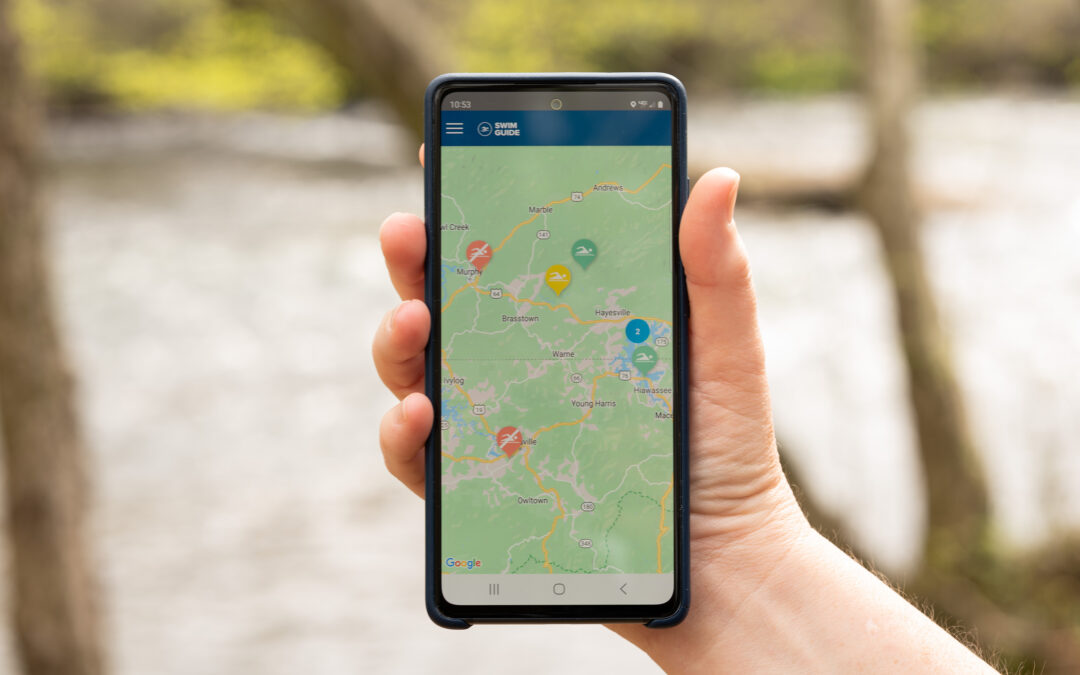
MountainTrue, a leading local environmental group, is encouraging the public to use the Swim Guide app before heading out onto the water to ensure a healthy and happy Independence Day weekend. MountainTrue is the home of the Broad Riverkeeper, French Broad Riverkeeper, Green Riverkeeper, Watauga Riverkeeper, and a Western Clean Water Team based in Murphy, North Carolina, that are dedicated to protecting the waters of the Southern Blue Ridge Mountains.

Each week between Memorial and Labor Day weekends, MountainTrue’s staff and volunteers collect and analyze water samples from 96 popular recreation spots across western North Carolina and Towns and Union Counties in northern Georgia. These samples are processed and analyzed, and the results are posted on the Swim Guide website (theswimguide.org) and the smartphone app in time for the weekend. This resource-intensive program is made possible by donations from MountainTrue’s members and the generosity of local businesses and organizations that sponsor one or more Swim Guide recreation sites.

Our Swim Guide Sponsors include Animal Hospital of BooneAppalachian Veterinary UltrasoundAsheville Fly Fishing CompanyBirdies Coffee & Treats on the FlyBlue Ridge Tourist CourtBoone CocoonBoone’s Fly Shop, City of Hiwassee, Fabbit Customs, Green River Cove Tubing, Joy Pharr Realty, Lake Adger Property Association, Mellow Mushroom Boone, Pink Mercury, The Purple Onion, Rivergirl Fishing Company, Rutherford Outdoor Coalition, Shelby Women for Progress, The SPOT, Trophy Water Guide ServiceThe Speckled Trout OutfittersTennessee Valley AuthorityWatauga Tourism Development Authority/Explore Boone, Towns County (GA), Union County (GA), Watauga River Lodge, and Zach Hobbs.

E. coli bacteria makes its way into our rivers and streams from sewer and septic leaks and in stormwater runoff — especially runoff from poorly managed animal agricultural operations. E. coli is an indicator of the presence of more harmful microbes, such as Cryptosporidium, Giardia, Shigella, and Norovirus. Contact or consumption of contaminated water can lead to gastrointestinal illness, skin infections, respiratory issues, and other health problems.

MountainTrue tests mid-week, analyzes the samples, and posts the results in time for the weekend. These tests are a snapshot in time. If tests are conducted on a Wednesday after a dry spell, the results usually look pretty good, but conditions can change rapidly following heavy rains when stormwater runoff brings pollution into our waterways. MountainTrue encourages river recreators to take extra precautions after hard rains and not to ingest or expose any open cuts or abrasions to water.

The Swim Guide lists each testing site as either passing or failing based on the U.S. Environmental Protection Agency’s 2012 Recreational Water Quality Criteria for primary contact of 126 CFU/100 mL. Waterways located in remote areas or near protected public lands with minimal agricultural and industrial pollution sources tend to be the cleanest and less impacted by stormwater runoff. Areas closer to development and polluting agricultural practices face greater risks, especially after heavy rainstorms that result in increased water runoff.

While the primary purpose of the Swim Guide is to inform the public about where it’s safe to swim, MountainTrue also uses the data collected to solve water quality problems, inform our advocacy, and push for science-based policy solutions aimed at protecting the health of our communities and supporting our river recreation economy.

The rivers of the Southern Blue Rigde are an important cultural, recreational, and economic resource for our region. In order to clean up the dirtiest rivers and protect the cleanest ones, Mountaintrue encourages policymakers to increase riparian buffers, encourage better building and farming practices and invest in upgrading aging sewer infrastructure to meet current and future needs.

To find the latest bacteria testing sites for your favorite swim area or to download the Swim Guide app, visit theswimguide.org.

A Plastic Bag Ban with a 10¢ Fee Is Best for the Environment with Limited Cost to Consumers

A Plastic Bag Ban with a 10¢ Fee Is Best for the Environment with Limited Cost to Consumers

A Plastic Bag Ban with a 10¢ Fee Is Best for the Environment with Limited Cost to Consumers

A plastic bag ban with a 10-cent fee on paper would dramatically decrease emissions of greenhouse gasses and sulfur dioxide, and the consumption of fossil fuels and fresh water at an annual cost of $3.33 per consumer — customers using EBT, SNAP, and WIC would be exempt.

Buncombe County, NC — A ban on single-use plastic grocery bags that includes a 10-cent fee on paper grocery bags would offer the highest environmental benefit to Buncombe County with limited costs for consumers, according to data assembled and analyzed by the local conservation organization MountainTrue.

Using environmental impact data provided by the American Chemistry Council — a group that lobbies and advocates on behalf of plastic bag manufacturers and the petrochemical industry — MountainTrue has calculated the environmental impacts of three scenarios: maintaining the status quo by doing nothing, adopting a plastic bag ban without a fee, and adopting a plastic bag ban that includes the 10-cent fee on paper.


Scenario 1 – Do Nothing: This scenario is based on current bag use multiplied by the per-bag environmental impacts as determined by the American Chemistry Council.

Scenario 2 – Post-Ban w/o Fee: This scenario assumes a conservative 50% increase in the use of paper bags after the passage of a plastic bag ban without a fee on paper bags. This is a high estimate based on data from cities that banned plastic bags without a fee on paper, which has shown increases in the range of 30%-50%.

Scenario 3 – Post-Ban w/ 10¢ Fee on Paper: This scenario assumes the passage of a plastic bag ban that includes a 10-cent fee on paper grocery bags and a corresponding 10% increase in the use of paper bags. 

While either bag ban scenario would be dramatically better for the environment than maintaining our current addiction to cheap, single-use plastic, adopting a plastic bag ban that is paired with a 10-cent fee on paper grocery bags would bring about the largest reductions in waste, pollution, and energy consumption. A bag ban with a 10-cent fee on paper bags would reduce Sulfur dioxide (SO2) emissions by 43%, fossil fuel consumption by 86%, solid waste by 66%, greenhouse gas emissions by 83%, fresh water consumption by 32%, and energy use by 73.3%. 

MountainTrue supports a plastic bag ban with a 10-cent fee on paper bags at the checkout aisle and has provided model ordinances to Asheville City Council and Buncombe County Commissioners that would additionally mandate that grocers use paper bags with at least 40% recycled content. This would further reduce environmental impacts. According to the Environmental Paper Network’s calculator, using recycled paper bags would reduce fossil fuel consumption by an additional 6.7% and greenhouse gas emissions by 30% compared to virgin paper.

These environmental benefits take into account expected increases in the consumption of paper bags after either bag ban would go into effect.

Using data and case studies from hundreds of localities that have already passed similar laws, MountainTrue estimates a 30-50% increase in paper bag consumption from a bag ban without a 10-cent fee on paper bags. MountainTrue’s preferred policy option, a bag ban with the fee, would result in a much smaller increase in paper bag consumption — approximately 10%.  

Currently, Buncombe County residents use approximately 132.4 million plastic shopping bags and 8.23 million paper shopping bags each year. Passing a plastic bag ban with a 10-cent fee on paper bags would zero out the number of new plastic bags used and result in a minimal increase in the number of paper bags to 9.05 million used per year.  

Cost to Consumers: $3.33/year

MountainTrue and the broader Plastic-Free WNC coalition are committed to passing an economically equitable policy that is not unduly burdensome to residents with lower incomes and fewer resources. We are committed to reducing this cost by partnering with City and County staff, local businesses, civic groups, and area nonprofits to educate and distribute free reusable bags to the people and families that need them most.

Case studies from around that nation have shown that the 10-cent fee on paper bags is critical to changing behavior and encouraging people to remember to bring their reusable bags to the grocery store. Additionally, the environmental benefits accrued from the fee far outweigh the minimal costs to consumers.

Our proposed ordinance would exempt customers using EBT, SNAP, and WIC from paying the 10-cent fee on paper bags. Even without that exception, the average cost to Buncombe County consumers would only be $3.33 per year, and customers can reduce or eliminate those costs by bringing reusable bags to the store. To put this in perspective, the average North Carolina resident already pays $745 per year in sales tax. (https://taxfoundation.org/sales-tax-per-capita-2019/)

MountainTrue and the broader Plastic-Free WNC coalition are advocating for the passage of an ordinance in both Asheville and Buncombe County that would ban single-use plastic grocery bags and styrofoam containers and would include a 10-cent fee on paper grocery bags. On October 11, 2022, Asheville City Council voted to begin public engagement and is due to receive a recommendation from City Staff this year. The City fielded a public survey from March 20 to April 30. Data from this survey will inform final recommendations to the city council.

MountainTrue’s Statement on the Nantahala-Pisgah Forest Plan

MountainTrue’s Statement on the Nantahala-Pisgah Forest Plan

MountainTrue’s Statement on the Nantahala-Pisgah Forest Plan

On March 20, after 10 years of public input and planning, the Forest Service will adopt its new management plan for the Nantahala-Pisgah National Forests — a disappointing document that is significantly worse than the current plan and contradicts an executive order issued by President Biden that would protect and expand our nation’s old growth forests. 

The new plan does have a few bright spots: the Eastern Band of Cherokee Indians will have more influence over forest management, new recommendations for Wilderness and Wild and Scenic River designations are welcome, and the plan implements more prescribed fire and wildfire protection activities. On other key issues — like tackling our massive road maintenance backlog, developing a plan to maintain and expand our trail networks and recreation infrastructure to meet current user demand, and drafting a monitoring plan to evaluate their own management practices — the Forest Service has failed to deliver, instead putting these critical concerns on the back burner for at least the next three years. 

However, for MountainTrue, the most egregious shortcoming is that the Forest Service has placed significant old-growth forests, rare species habitat, and roadless backcountry into zones that are open to commercial logging. The Forest Service has also relaxed rules to allow ground-based logging on steep, hard-to-reach slopes — where many of our old-growth forests remain.

To be clear, MountainTrue is not against commercial logging, and we’re not concerned about the amount of logging permitted by the new forest plan. It’s essentially the same amount allowed by the old plan. Regardless of how much logging occurs — whether it’s the modest 800 acres annually of today or the eyebrow-raising 3,200-acre annual maximum, what matters most is where logging occurs. MountainTrue has provided detailed maps of existing old-growth communities and filed formal objections, and despite our best efforts, the Forest Service chose to expand the footprint of where logging can occur to 600,000 acres, more than half of the land of the Nantahala-Pisgah National Forest. This includes 100,000 acres of natural heritage areas, roadless areas, and sensitive habitats where we will vigorously oppose any future logging projects. 

It doesn’t need to be this way. Logging is a critical part of Western North Carolina’s economy and can play an important role in establishing the kinds of wildlife habitat desired by local hunters. Half a million acres can provide more than enough timber harvests and early-successional habitat while still protecting our most treasured natural areas and recreational resources. A detailed blueprint for accomplishing this was provided to the Forest Service by the Nantahala-Pisgah Forest Partnership, a coalition that brought together recreation, conservation, civic, and business interests — including timber and paper industry representatives. 

Instead, the Forest Service devised a forest plan that seems designed to pit user-interest groups against each other by allowing logging in some of our most diverse forests and pristine backcountry areas. The agency also wants the right, as it is pushing through in the Southside Project, to cut existing old-growth forest, even though the Environmental Impact Statement for the planning process discloses that there is a minimum of a 300,000-acre deficit of old-growth on Forest Service Land alone, making it the most under-represented age class in the region compared to the average over the last few millennia. 

To paper over this egregious management strategy, the Forest Service has devised its own “designated old-growth network” which fails to include existing and well-documented old-growth areas and can change significantly from plan to plan. This scheme allows the Forest Service to place relatively young trees in the old-growth network until they are old enough to log profitably decades from now. It also flies in the face of President Biden’s executive order 14072 of April 22, 2022, which, in part, seeks to “conserve America’s mature and old-growth forests on Federal lands” and directs the Secretary of Agriculture to “define, identify, and complete an inventory of old-growth and mature forests on federal lands […]” That inventory is due this April, and, if done correctly, will include tens of thousands of acres that this Forest Plan leaves open to logging.

According to executive order 14072, it is the policy of the Biden Administration to “manage forests on Federal lands, which include many mature and old-growth forests, to promote their continued health and resilience; retain and enhance carbon storage; conserve biodiversity; mitigate the risk of wildfires; enhance climate resilience; enable subsistence and cultural uses; provide outdoor recreational opportunities; and promote sustainable local economic development.” That’s a vision of forest management that we wholeheartedly support and that this Forest Plan quite simply fails to accomplish. 

The Forest Service had the chance to unify the public behind a well-balanced Forest Plan. Instead, they sided with more narrowly aligned interests inside and outside the agency and, despite a 10-year planning process, kicked many difficult decisions down the road. But the fight for our forests is far from over. You can count on MountainTrue to continue working to protect the places we share.

For media inquiries, contact: Karim Olaechea, Deputy Director of Strategy & Communications 
Phone: 828-400-0768 | Email: karim@mountaintrue.org

Microplastic pollution is widespread throughout the waters of Western North Carolina

Microplastic pollution is widespread throughout the waters of Western North Carolina

Microplastic pollution is widespread throughout the waters of Western North Carolina

Testing by MountainTrue shows that microplastics are present throughout the Broad, French Broad, Green, Hiwassee, Little Tennessee, New River and Watauga River Basins.

Western North Carolina — Regional conservation organization MountainTrue has documented the high levels of microplastics in surface water samples collected from waterways throughout western North Carolina. Microplastics are pieces of plastic smaller than 5 millimeters that are the result of the breakdown of larger plastic litter and debris into smaller and smaller pieces. They are harmful to aquatic life and are considered a potential threat to human health. 

MountainTrue collected and analyzed water samples from the Broad, French Broad, Green, Hiwassee, Little Tennessee, New River and Watauga River Basins. We found microplastics in every sample from every region, even in otherwise pristine areas and protected watersheds. We documented an average of 19 particles of microplastic per liter of water across all tested watersheds. The highest particle counts of microplastics were found in the Little Tennessee (37 particles/liter) and Hiwassee (30 particles/liter) watersheds. Even in watersheds with lower levels of microplastic contamination, there were testing sites with concentrations in the high twenties and thirties. 

Watershed

Avg no. of microfibers per liter

Avg no of microbeads per liter

Avg. no of microfragments per liters

Avg. no. of microfilms per liter

Avg no. of all microplastics per liter

Broad River

12

1

5

6

24

French Broad River

7

0

4

5

16

Green River

20

0

5

2

27

Hiwassee River

18

0

2

10

30

Little Tennessee River

29

1

3

5

37

New River

20

0

3

6

29

Watauga River

14

0

0

3

17

All Watersheds

12

0

2

5

19

Microfibers, which come from synthetic clothing and fishing line, was the most common form of microplastic that we observed. Microfilms, which degrade from plastic bags and food wrappers, accounted for more than a quarter of microplastics recorded. 

There have been significant amounts of microplastics research in marine systems, but microplastics in freshwater systems have been less studied overall. MountainTrue’s study is one of the first to look at levels across western North Carolina in order to gain a general understanding of the amount of microplastics in our water. MountainTrue is partnering with the Waterkeeper Alliance on a state-wide study for all of North Carolina.

Microplastics can enter the environment as plastic litter degrades, in runoff from landfills, and through discharges from wastewater treatment plants. Once in the environment, they can travel for thousands of miles suspended in water or carried by the wind. 

MountainTrue is partnering with businesses in Hendersonville to help them shift their operations away from single-use plastics toward reusable bags and compostable utensils and packaging through the Working to be Plastic Free partnership. In Buncombe County and the Town of Boone, MountainTrue is advocating for local ordinances that would encourage the use of reusable shopping bags by replacing single-use plastic bags with paper bags and charging a 10 cent fee that would be waived for shoppers enrolled in the SNAP or WIC programs. To learn how you can support these efforts visit plasticfreewnc.com

“The first step to stop the contamination of our environment and our bodies is to reduce the amount of plastic that enters and escapes the waste stream,” explains Anna Alsobrook, MountainTrue’s French Broad Watershed Outreach Coordinator. “And that starts by breaking our dependence on single-use plastics like plastic grocery bags and fast food utensils and packaging.” 

Microplastics are inadvertently ingested by fish and other aquatic organisms causing microplastics to be transferred throughout the food web. Researchers have found that microplastic ingestion can negatively affect freshwater fish through physical complications of passing plastic through the gut or false satiation. Microplastics can also leach harmful chemicals like plasticizers and additives into the organs of fish. The chemicals have varying effects on fish changing feeding rates, development and survival. Much of the research is focused on centrarchids. Centrarchids are the family of sunfish, and they are a sentinel species, so they are often used to detect risks to humans by providing advance warning of danger.

People consume microplastics in contaminated food and water, and by breathing them in. Microplastics have been found in seafood, salt, tap water and even in bottled water. It is estimated that, globally, people ingest an average of five grams, or the equivalent of a credit card, worth of plastic every week. 

The effects of plastic pollution on human health is the subject of a growing body of research. A study has found microplastics small enough to be carried in the bloodstream in the placentas of pregnant mothers. Other research has shown that microplastics cause damage to human cells, including cell death and allergic reactions, at levels known to be consumed in food. 

Other research has shown that it’s not just the plastics, but also the additives used to make them can have a harmful effect on human health. Phthalates, which are a family of chemicals used in food packaging, are known endocrine disruptors that harm the reproductive and nervous systems and have been linked to higher rates of childhood asthma and other respiratory conditions. Styrene, which is used to make styrofoam cups, food containers, and disposable coolers, leaches into the food and drinks they hold and from landfills into drinking water. The World Health Organization has classified styrene as a probable human carcinogen

“These plastics can persist in our environment for hundreds if not thousands of years,” says Anna Alsobrook. “The more we learn about what plastics and the chemicals used to make them are doing to our environment and to our bodies, the clearer it becomes that we need to take action now.”

Ward Mill Dam Removal Connects Aquatic Habitat, Makes River Healthier

Ward Mill Dam Removal Connects Aquatic Habitat, Makes River Healthier

Ward Mill Dam Removal Connects Aquatic Habitat, Makes River Healthier

Boone, NC — In a huge win for local aquatic wildlife, the Ward Mill Dam just a few miles from Boone, North Carolina has finally been removed. The first dam was constructed at the location in 1890 and improved upon over the years. The mill complex served the community for generations providing electricity, jobs, firewood and building materials. The dam had been an obstacle for local aquatic wildlife for the past 130 years. Now, native fish such as the tangerine darter and threatened salamanders like the hellbender will be reunited and benefit from a reconnected and improved cold-water aquatic habitat.

The Ward Mill Dam Removal project has been a partnership between American Rivers, Blue Ridge Resource Conservation and Development, MountainTrue, the Watauga County Soil and Water Conservation District and the U.S Fish and Wildlife Service. The dam removal was a high priority for experts and biologists and was ranked a top priority among projects by the Southeast Aquatic Resource Partnership and “tier one, priority one” by the North Carolina Aquatic Barrier Assessment Tool.

MountainTrue’s Watauga Riverkeeper, Andy Hill, is excited about the environmental benefits and the opportunity to connect the Watauga River Paddle to create more recreational opportunities. “We’ve greatly improved aquatic habitat and river health, and promoted safe river recreation while honoring the historical and community cultural value of the Ward Mill.”

The Ward family continues their generations-long environmental stewardship by removing this aquatic barrier and graciously surrendering their hydropower license with the Federal Energy Regulatory Commission. While the instream dam structure has been completely removed down to bedrock to reconnect the watershed and allow for sediment transport downstream, the iconic sawmill, historic buildings and complex have been preserved in partnership with the State Historic Preservation Office. Please respect the decision and the privacy of the Ward family.

“We are excited to see the long-term environmental benefits associated with removing the dam, but are also excited about preserving the rich history of the dam complex by documenting and saving the nearby historic buildings,” explains Jonathan Hartsell of Blue Ridge Resource Conservation and Development. “This complex project has been successful from start to finish due to a well thought out gameplan from the project management team, agency partners and, most importantly, the landowners.”

The complex project had to be done carefully due to the delicate biodiversity of the Watauga River and its streams. Dr. Mike Gangloff and Dr. Derek Martin of Appalachian State University led a team of researchers collecting valuable data on pre and post-removal aquatic habitat. This has included sediment flow research, aquatic habitat surveys and numerous nocturnal SCUBA dives searching for elusive nocturnal Hellbender salamander. Sediment flow research and aquatic habitat surveys will better inform future dam removal projects and contribute to the field of knowledge for river restoration.

“Rivers are like a circulatory system, and thanks to this dam removal, American Rivers with our partners celebrate a free-flowing Watauga River which is the lifeblood of a thriving community, healthy ecosystems, and clean water for people and nature,” says Dam Removal advocate and American Rivers Science Program Director and Southeast Conservation Director Erin McCombs.

Removing the Ward Mill Dam reconnects 35 miles of aquatic habitat in the main stem of the Watauga River and 140 miles of streams across the watershed. Dams, though providing benefits in certain circumstances, can also significantly damage rivers. Dams increase water temperature, reduce river flows, reduce the amount of dissolved oxygen available to fish and other species, block the natural flow of sediment and debris, and serve as physical barriers for recreational users such as paddlers and anglers, as well as aquatic wildlife such as fish and amphibians. Additionally, most dams require maintenance and many require removal or rebuilding after 50 years.

The dam deconstruction was performed by the United States Fish & Wildlife Service National Fish Passage Program Aquatic Restoration team and Wildlands Engineering. Project funding was generously provided by the North Carolina Division of Water Resources, Patagonia, the Bonneville Environmental Foundation, Beech Mountain Resort, Hunter Banks of Asheville, and Boone’s Fly Shop.

DNA Testing Indicates Animal Agriculture and Sewer Infrastructure are Major Pollution Sources for French Broad River

DNA Testing Indicates Animal Agriculture and Sewer Infrastructure are Major Pollution Sources for French Broad River

DNA Testing Indicates Animal Agriculture and Sewer Infrastructure are Major Pollution Sources for French Broad River

MountainTrue’s French Broad Riverkeeper hopes science will inform policy solutions to clean up area waterways.

Asheville, NC — Testing conducted by local conservation organization MountainTrue has confirmed that cattle and faulty or inadequate sewer, septic or water treatment infrastructure are the major sources of E. coli pollution in the French Broad River.

MountainTrue’s French Broad Riverkeeper conducts regular water quality monitoring of rivers and streams throughout the French Broad River Basin, including weekly testing of more than 30 recreation areas from May to September. After decades of slow but consistent improvement to the basin’s water quality, the organization has documented a sharp decline in water quality.

“The difference over that past few years has been disturbing,” explains French Broad Riverkeeper Hartwell Carson. “Take Pearson Bridge in Asheville’s River Arts District: That site passed the EPA’s safe threshold for swimming 81% of the time in 2016. Just four years later, that site failed 81% of the time in 2020. Or Mud Creek in Henderson County, that site passed 52% of the time in 2018, and now it fails 93% of our tests.”

MountainTrue’s standard E. coli testing program measures the E. coli in the river. Levels in the French Broad have been high and rising year-over-year, but the nonprofit couldn’t say for certain what the sources of the pollution were. Determining the major sources of E. coli required more expensive testing to look at the presence of DNA in the river.

“Testing DNA in polluted water is pretty state-of-the-art and it isn’t cheap,” explains Hartwell Carson. “We needed help paying for it, so we approached Senator Chuck Edwards for help.” North Carolina Senator Edwards, whose district includes Henderson and parts of Buncombe County, helped secure state funding to pay for sampling and lab costs. With that funding, MountainTrue looked at the DNA found in 55 water samples to look for genetic fingerprints of E. coli from people, cows, dogs, poultry, sheep and swine.

“Our rivers are very important to our quality of life and our economy,” explains Senator Edwards. “This project is helping us better understand the causes of bacteria pollution in the French Broad River. We need that information to develop solutions that will keep the river clean.”

Of the 55 samples, 44 revealed DNA from cows. Human DNA was the second most prevalent. The results vary, but at nearly every site the primary sources of pollution were cattle followed by human. Dog DNA also showed up as a moderate contributor to E. coli pollution at a few sample sites.

“The French Broad has some clean and clear streams that run through protected public lands, but we’re seeing more and more problem sites that consistently fail the EPA’s safe water standard for E. coli,” says Hartwell Carson. “Until now, we’ve only had educated guesses about where the E. coli was coming from. With this testing, we have the data we need to make more informed decisions about how to clean up our rivers.”

MountainTrue is presenting the results from their DNA testing to local members of the General Assembly and is encouraging the public to advocate for the adoption of a clean rivers policy agenda that includes funding to help farmers, property owners and local governments reduce water pollution.

“Now that we know the sources of E. coli pollution,” says Hartwell Carson. “The next step is to invest in actions that fix the problem.” The public can read about issues affecting water quality, and the policies and reforms needed to fix them at iloverivers.org.

TAKE ACTION TO FIGHT E. COLI POLLUTION IN OUR RIVERS

We’ve done the DNA testing. We know the sources of E. coli pollution. Now we have the solutions to clean up our rivers. Stand up for science-based policies to help farmers fence cattle out of streams and property owners fix their septic systems.  And advocate for much-needed investments in wastewater infrastructure.

The Results:

MountainTrue focused their testing on problem sites that had shown high levels of E. coli in previous testing: Hominy Creek, Mud Creek below downtown Hendersonville, Cane Creek and the French Broad River at Pearson Bridge in Asheville’s River Arts District. DNA levels of 0-49 numbers of DNA copies/100mL are considered “very low,” 50-99 “low,” 100-499 “medium,” 500-999 “high,” and 1,000 or above was “very high.” DNA testing provides a general picture of a body of water for approximately 100 meters upstream.

Hominy Creek
Averages for six samples: Cow – 339, Dog, 89, Human – 34.
Every sample taken at Hominy Creek showed cow DNA counts at or above medium levels. The highest level of cow DNA recorded was 511, putting that sample in the high range. Human DNA was also found in every sample, though at low or very low amounts in all samples except one in the medium range. This indicates that upstream agriculture in the watershed is significantly contributing to E. coli impairment, and while human waste from faulty sewers and failing septic systems plays a role, it isn’t the dominant pollution source. This testing site is below the Hominy Creek Greenway, a very popular dog-walking area and the likely reason for higher levels of dog DNA.

French Broad at Pearson Bridge
Averages for six samples: Cow- 270, Dog – 59, Human – 67
Cow DNA was the largest contributor at this site, but levels were more varied than at Hominy Creek. One sample showed cow DNA in the high range at 764, while three other samples presented low levels of cow DNA. Human DNA and dog DNA were also present at this site but at much lower levels. The variability of DNA levels is likely due to the impact of stormwater runoff. When it rains, cow and dog waste are washed in from the surrounding landscape causing a rise in pollution levels.

Cane Creek at Fletcher Park
Averages for six samples: Cow – 334, Human – 47, Dog – 8
The primary source of E. coli pollution in Cane Creek is quite clearly cattle from area farms. Human levels of DNA were very low and nonexistent in two instances.

Mud Creek below Downtown Hendersonville
Average for seven samples: Cow – 251, Human – 120, Dog – 52
Mud Creek was the site with the highest level of human DNA in all our testing. But, even here, levels of cow DNA were more prevalent than human. In three instances, human DNA counties were higher, but the overall average for cow DNA was higher. The pollution sources for Mud Creek are likely cattle, closely followed by human waste from faulty sewers, failing septic systems and inadequate wastewater treatment plants.

About MountainTrue
MountainTrue champions resilient forests, clean waters and healthy communities. We are committed to keeping our mountain region a beautiful place to live, work and play. Our members protect our forests, clean up our rivers, plan vibrant and livable communities, and advocate for a sound and sustainable future for all. MountainTrue is active in the Broad, French Broad, Green, Hiwassee, Little Tennessee, New and Watauga watersheds, and is home to the Broad Riverkeeper, French Broad Riverkeeper, Green Riverkeeper, and Watauga Riverkeeper.
Mountaintrue.org


Media Contact:
Karim Olaechea, MountainTrue Communications Director
E: karim@mountaintrue.org, C: 415-535-9004